About Logger And Measurement tools 1.0
About measures
Please install this application from Android Market. It can prevent infecting
your terminal by a computer virus, or data flowing out with the falsified
application.
It is better for you to have moved data and to delete. Moreover, probably,
it is good not to record positional information at the private place near
your house.
How to use
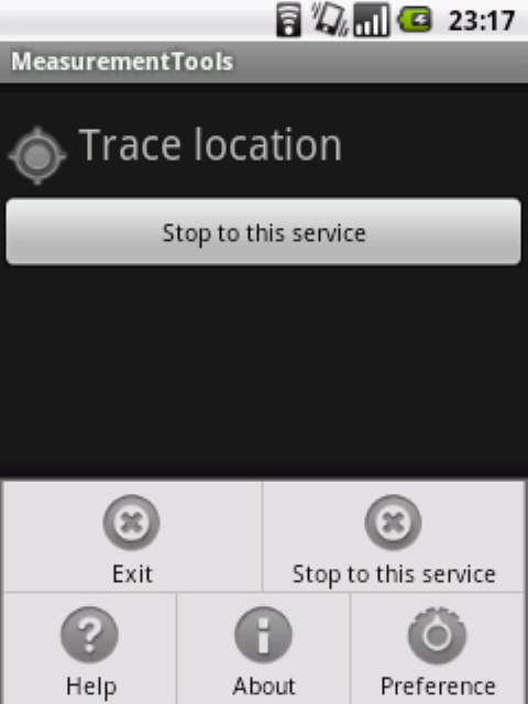
Main menu

- Exit
- It was exited this application. "RecordLocationService" is working
without exit.
- Stop to the service
- It stops the service to record. If you do not stop it, the service continues
working.
- Help
- It displays the how to use and notes of application. It is necessary to
connect it to Web.
- About
- It displays the information on this application. It displays the information
on GPS and a sensor, etc.
- Stop the service menu and button(long click)
- "RecordLocationService" stops.
Trace and record your location
- Speed
- It shows the moving velocity with km/h or m/s. Depending on the GPS accuracy,
it may have an error.
- Pitch
- It shows the pitch with percent. It may also have an error.
- Latitude
- It shows the latitude of the location. If the value is positive, it shows
the north latitude. If it is negative, it shows the south latitude.
- Longitude
- It shows the longitude of the location. If the value is positive, it shows
the east longitude. If it is negative, it shows the west longitude.
- Data n/1000
- It shows the number of the positional information acquired until now. If
you save the data, the number decreases.
- Start to record / Stop to record
- It saves the acquired positional information automatically at a file.
- Save
- You can save the information at a file. Even if you check "Start to
record", you can do it.
- Preference
- It displays a Preference screen.
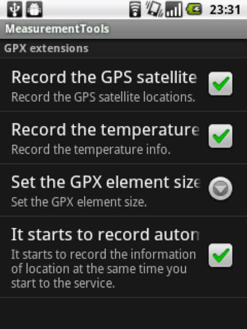
Preference

- Record the GPS satellite locations
- It saves GPS Satellite information, including the location of the acquired
satellite, an altitude, etc., to the <extensions> element. It is
an original function. The default is ON.
- Record the temperature information
- It records the temperature information. If it changes, it records. It is
an original function. The default value is ON.
- Start to record automatically
- It starts to record the information of location at the same time you start
to the service. It is the same operation as you chose "Trace and record
your location" on a main screen and selected the "Start to record"
menu.
- Set the GPX element size
- Set the GPX element size. The default size is 1000. The data is divided
and saved based on the value.
About a filename
"lr_yyyyMMddThhmmssz.gpx"
yyyy:years, MM:months, dd:days, hh:hours, mm:minutes, ss:seconds, z:time
zone
It is the time when the information was saved to the file.
Hardware requirement
Indispensable condition
- Android 2.2(Froyo) or later
- GPS
- SD Card or External storage
- 3G or network access(It is required for License Check.)
Recommend environment
- Accelerometer and Magnetic field sensor
The sample of gpx file
samplegpx_20110609+0900.zip
It includes GPS information. It passes along the Okayama bypass.
About the purchase in Android market
Please perform the next operation and verify these.
- Select a "About" menu.
- You verify to show "GPS: OK".
- You verify the name of an accelerometer and a magnetic field sensor.
If the following message is displayed, you cannot use.
- GPS: NO
- No names of a sensor are displayed.
Troubleshooting and Q&A
-
Q. The icon of GPS is not displayed.
A. Please verify whether the same phenomenon occurs with other applications.
Please turn on your terminal again or reset.
-
Q. When it saves data, this application does not answer.
A. It may occur in a specific environment. When GPX data size is changed
smaller, it may stop occurring.
-
Q. When it saves data, this application does not answer.
A. It may occur in a specific environment. When GPX data size is changed
smaller, it may stop occurring.
-
Q. This application crashes, if it starts.
A. The state of preference may not be right. Please choose the menu of
Android, "Manage applications", and "clear data". It
may be able to improve it.
About use
If this application is used continuously for a long time, your terminal
may generate heat. Please take care about the symptoms of a low-temperature
burn.
You must not use this application under the situation where you are concerned
with human lives, such as rescue.
It does not guarantee that the information is correctly recordable in all
the environments.
Gratefulness
Thank you for purchasing this application. We are going to improve this
application.
Contact us
Updating information
-
May 4, 2011 (1.0.5)
-
We have improved the function so that our bearings may be displayed at
the time of movement.
-
The fault of the file copy was corrected.
-
We improved so that the scale of the picture of an azimuthal angle could
be changed.
-
The Preference screen was updated.
-
April 30, 2011 (1.0.3)
We corrected.
-
April 29, 2011 (1.0.2)
First release
-
March 29, 2011 (1.0.0)
Test version
Development schedule
We will add a function from now on also. Please expect.
Last updated date: May 2, 2011
Index page


